Overview
Crown Lands Commissioners were the first government officials to be appointed to regional areas surrounding the Moreton Bay Settlement after it was opened to free settlers in 1842.
This project examines the roles and responsibilities of the Crown Lands Commissioners appointed to administer the newly created pastoral districts surrounding the Moreton Bay Settlement from 1842 to 1859. It features a series of maps outlining the boundaries of the first pastoral districts, and a selection of letters written by Crown Lands Commissioners. These archival documents illustrate the wide range of tasks involved in the administration of the pastoral districts and provide first-hand accounts of the difficulties that the Commissioners faced in the execution of their duties on the contested lands of the pastoral frontier.
They also provide an insight into the men who accepted the position. Their wide-ranging powers gave them control over every aspect of life on the northern frontier of New South Wales including the take-up of pastoral land, the administration of justice, relations with Indigenous people, exploration of the land and the provision of government services. Short biographies of five of the earliest Crown Lands Commissioners in Queensland can be found under ‘Biographies’ on this website.
About the author
Dr. Margaret Shield was appointed as a Visiting Fellow at the Harry Gentle Resource Centre of Griffith University in 2017 and has previously published articles on the formation and leadership of community organisations in Rockhampton and on Scottish immigrants in central Queensland. The current project expands on her research into the development of regional communities in colonial Queensland.
Dr. Shield was assisted in her research by Kaye Nardella and Bill Kitson from the Queensland Museum of Lands, Mapping and Surveying who provided valuable information and guidance in the production of the pastoral district maps. Deklan Kelly, an undergraduate intern in the Harry Gentle Resource Centre, transcribed some of the Commissioners’ Letterbooks held in the Queensland State Archives and the State Archives and Records Authority of New South Wales.
INTRODUCTION TO PASTORAL DISTRICTS
The system of land ownership in New South Wales was based on the premise that all land belonged to the Crown. Land that was not required by the government for towns, roads, reserves or other purposes could be sold or leased and thus formed the primary source of revenue for the colony.
However, from the earliest years of pastoral settlement in New South Wales unauthorised occupation of Crown Lands was widespread. In September 1826 Governor Charles Darling issued an order creating an area known as the ‘limits of location’. Settlers were only permitted to take up lands within this area. These ‘limits of location’ were expanded in 1829. However, settlers regularly defied these orders and ‘squatted’ on land outside the boundaries without leasehold or legal title. As a result, the New South Wales government introduced measures which required settlers to obtain grazing leases and de-pasturing licences in an effort to regulate the take up of land. During the 1830s and 1840s, in an effort to maintain control of Crown Lands, the government enacted further legislation to create pastoral districts and to appoint Commissioners of Crown Lands to administer them.[1]
LAND LEGISLATION
On 8 August 1833 Governor Richard Bourke enacted a law entitled An Act for Protecting the Crown Lands of this Colony from Encroachment, Intrusion and Trespass (Act 4 Will. IV no. 10) which prohibited squatting on Crown Lands and allowed for the appointment of Commissioners of Crown Lands who were tasked with ensuring that the rights of the Crown were not lost as settlement progressed.
Further legislation was introduced in 1836. The Act to restrain the unauthorized occupation of Crown Lands (Act 7 Wm. IV no. 4) ensured that occupiers of land purchased a licence to settle. This ensured that the legal rights of the Crown were preserved and that revenue from the licences could be collected to offset the cost of enforcing the system. Provisions of the 1836 Act were strengthened by a further Act (2 Vic. no. 19) entitled An Act to continue and amend an Act intituled ‘An Act to restrain the unauthorised occupation of Crown Lands’.
In 1839 further legislation was passed. An Act further to restrain the unauthorised occupation of Crown Lands and to provide the means of defraying the expense of a Border Police (2 Vic. No. 27) enabled the establishment of a Border Police Force under the control of the Crown Lands Commissioners to assist them to maintain law and order in the pastoral districts. This Force remained in place until it was replaced by the Native Police Force in 1846.
Between the years 1839 and 1842 the Crown also instituted a system of annual pastoral licences but under the 1847 Orders in Council, the government acceded to the demands of pastoralists for more secure, long-term tenure and cheaper rent. From then on, leases were granted for one year in ‘settled districts’, eight years in ‘intermediate districts’ and 14 years in ‘unsettled districts’.[2]
[1] Queensland Museum of Lands, Mapping and Surveying, ‘Surveying history’, available online at https://www.qld.gov.au/recreation/arts/heritage/museum-of-lands/survey-history; Queensland State Archives Agency ID 10425, Commissioners of Crown Lands, Wide Bay and Burnett, ‘Description’.
[2] New South Wales Government Gazette, 11 September 1833, no. 80, p. 356; New South Wales Government Gazette 1839, no. 405 (Supplement), p. 393; Queensland Museum of Lands, Mapping and Surveying, ‘Surveying history’; Queensland State Archives Agency ID 10425, Commissioners of Crown Lands, Wide Bay and Burnett, ‘Description’.
Moreton Bay was established as a penal station in 1824. It was known officially as the Moreton Bay Penal Settlement of the Colony of New South Wales. Free settlement within 50 miles (84 kilometres) of the prison was prohibited. It was not until 10 February 1842 that the area was officially opened to free settlement and became known as the Free Settlement of Moreton Bay.[1]
However, pastoralists had already ‘squatted’ on land south-west of Moreton Bay both on the Darling Downs and on land around the Brisbane River. Some had obtained pastoral leases but many simply moved their livestock onto land for which they had no legal title. Patrick and Walter Leslie arrived from New England with their stock in 1840 and established Canning Downs near Warwick. Others, including Frederick and Francis Bigge, David Archer and Evan and Colin Mackenzie settled around Grantham, Woodford and Kilcoy respectively while Henry Russell settled at Cecil Plains and David McConnel at Cressbrook in the Brisbane Valley.[2]
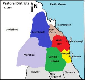
The rapid, unregulated advance of settlers was a cause of concern for the Governor, Sir George Gipps, who realized that action had to be taken to ensure the safety of settlers and to maintain control of settlement on Crown Lands. He promptly declared the new pastoral districts of Moreton Bay in 1842, Darling Downs in 1843, Wide Bay, Burnett and Maranoa in 1848, and Leichhardt and Port Curtis in 1854 and appointed Crown Lands Commissioners to administer them.
[1] QSA, Pre-Separation Resource Guide, Queensland State Archives, Brisbane 2013, p. 2.
Pre-separation resource guide – Dataset – Publications | Queensland Government.
[2] McKinnon, F., ‘Early Pioneers of the Wide Bay and Burnett’, Journal of the Historical Society of Queensland, vol. 3, no. 2, 1940, pp. 92-93.
PASTORAL DISTRICT MAPS
The pastoral districts which were gazetted in the early years of settlement covered vast areas, much of which was rugged and unexplored. Although the boundaries of some pastoral districts were altered over time, the territory over which each Commissioner of Crown Lands had jurisdiction remained inordinately large and difficult to manage. Christopher Rolleston, for example, presided over 26000 square miles (6 million hectares) of the Darling Downs and a vast area beyond its recognised boundaries.[1]
On 12 April, 1851 the boundaries of the Wide Bay and Burnett Districts were amended and on 10 January 1854, the Burnett District was absorbed into the new Leichhardt and Port Curtis pastoral districts.
Moreton Bay Pastoral District was declared on 5 May 1842 by Governor George Gipps:
“Bounded on the south by the ranges which separate the sources of the Rivers Brisbane and Logan from those of the Richmond and the Clarence; on the west by the range dividing the sources of the rivers flowing into the western interior from those which fall to the eastern coast; on the east by this coast; and on the northward by the limits of Colonisation, until a more definite boundary shall be determined on that side.”
(New South Wales Government Gazette 10 May, 1842, p.689)
Darling Downs Pastoral District was declared on 11 May 1843 by Governor George Gipps:
“Bounded on the south by a line extending due west, so as to intersect the top of Mount Girard, which is near the head of the north branch of the Clarence River, and dividing this from the New England District; on the east by the range dividing the eastern and western waters, separating this from the Clarence River District and from the County of Stanley; and on the north and west the boundaries are indefinite.”
(New South Wales Government Gazette 12 May, 1843, p. 645)
Wide Bay Pastoral District was declared on 7 November, 1848 by Governor Charles FitzRoy:
“Bounded on the south by the Glass House Range from the sea coast to the range at the head of the river Brisbane, which range there separates the Moreton and Burnett Districts; on the west by the range dividing the waters falling to Wide Bay from those of the valley of the Burnett as far as the pine scrub in that range, and by a small stream there arising, which enters the sea to the southward of the estuary of the Burnett; on the east and north-east by the sea coast.”
(New South Wales Government Gazette, 7 November, 1848, p. 1644)
Burnett Pastoral District was declared on 7 November, 1848 by Governor Charles FitzRoy:
“Bounded on the south by the range dividing the waters of the Rivers Brisbane and Burnett, extending south-westerly from Jemma to the greater dividing range; on the west by that range to the most northerly head of the Dawson River, (called there Palm Tree Creek); on the north by Palm Tree Creek, and by the River Dawson to its confluence with the River Burnett; and thence by the River Burnett downwards to the confluence of the Seven Hills Creek; on the east by the Seven Hills Creek upwards to its most easterly source in the range dividing the waters of the Burnett from those falling towards Wide Bay; and on the east by that range to Jemma.”
(New South Wales Government Gazette, 7 November, 1848, p.1644)
Maranoa Pastoral District was declared on 7 November, 1848 by Governor Charles FitzRoy:
“Bounded on the south by the surveyed and marked track from the river Barwan to Johnstone’s station, called Cunningundi, on the river Mooni; on the west thence by that river upwards to where the said marked track leaves the Mooni, thence by that track to St. George’s Bridge on the river Balonne, thence by the Balonne to the confluence of the river Maranoa, and by the Maranoa to the river Amby; on the north by the river Amby to its source in Mount Bindango, thence by a line across the Fitz Roy Downs to Mount Beagle, and from thence by a line across the same Downs to the highest summit of the Grafton Range and thence by a line east (by compass) to Sandy Creek; on the east by Sandy Creek downwards to its confluence with the Balonne, and by the line south (by compass) and by the surveyed track aforesaid crosses it at a tree marked No. 87.”
(New South Wales Government Gazette, 7 November, 1848, p. 1644)
Leichhardt Pastoral District was declared on 10 January 1854, by Governor Charles FitzRoy:
:Bounded on the east from the great dividing range by the range dividing the waters of the Burnett and Dawson Rivers, separating this District from that of Wide Bay and Burnett to the junction of the range dividing the waters of Tunks’ Creek from other tributaries of the Dawson, by that range and by a spur range to the confluence of Kroombit Creek with Tunks’ Creek, thence crossing Tunks’ Creek by a spur northerly and by the range forming the western watershed of Tunks’ Creek, and thence by the range to the great north-west bend of the Fitz Roy River, separating this district from that of Port Curtis; thence on the north by a spur range to the range forming the northern watershed of the Mackenzie River and by that range to the great dividing range; and on the west and south by the great dividing range, separating this district partly from those of Maranoa and Darling Downs, to the junction of the range dividing the waters of the Burnett and Dawson Rivers.:
(New South Wales Government Gazette, 10 January, 1854, p. 51)
Port Curtis Pastoral District was also declared on 10 January 1854 by Governor Charles FitzRoy:
“Bounded on the north and east by the sea; on the south by the range forming the northern water-shed of the Kolan River, to its junction with the range forming the northern watershed of the Burnett River and by that range separating this District from that of Burnett and Wide Bay, to the junction of the range dividing the waters of Tunks’ Creek from other tributaries of the Dawson; and on the west by the last mentioned range, and by a spur to the confluence of Kroombit Creek with Tunks’ Creek; thence crossing Tunks’ Creek by a spur northerly, and by the range forming the western watershed of Tunks’ Creek, and thence by the range to the great north-west bend of the FitzRoy River, separating this District from that of Leichhardt; and thence by features (to be determined) at an average distance of 30 miles from Herbert’s Creek and Broad Sound, and extending northerly to meet Broad Sound at a small inlet in that part of the coast which trends westerly; excepting therefrom the counties of Clinton, Deas-Thompson, and Livingstone.”
(New South Wales Government Gazette, 10 January, 1854, p. 50)
The maps below show the extent of the Pastoral Districts in 1848 and in 1854 after the creation of the Port Curtis and Leichhardt Districts.
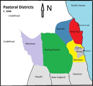
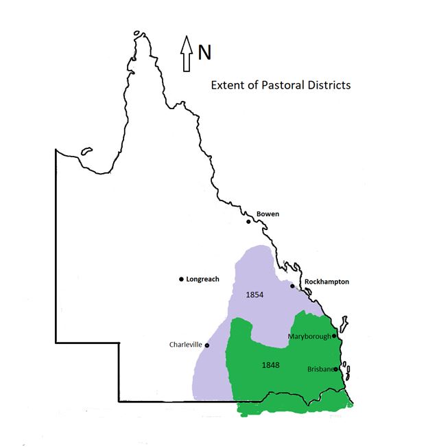
Pastoral Districts in relation to the Queensland border declared in 1859
[1] Beal, D., ‘Foreword’ A Transcription of Rolleston’s Records, Toowoomba and Darling Downs Family History Society, 2008, p. 3.
CROWN LANDS COMMISSIONERS APPOINTED 1842 TO 1859
A Commissioner of Crown Lands was appointed to each pastoral district to ensure the legal and orderly settlement of the land and to maintain law and order among the population. Commissioners reported to the Colonial Secretary until George Barney was appointed Chief Commissioner of Crown Lands on 1 January 1849. A list of those who held these positions is given below. When Queen Victoria signed the Letters Patent proclaiming Queensland a separate colony on 6 June 1859, control of land administration passed to the Queensland Government and a Crown Lands Office was established under Augustus Charles Gregory who was appointed as Surveyor-General on 23 December 1859 and as Chief Commissioner of Crown Lands on 19 January 1860. As pastoral activity declined and more government administrators were appointed throughout the colony, Commissioners of Crown Lands were no longer required and the position was phased out in the late 1870s.[1]
Crown Lands Commissioners in pre-Separation Queensland[2]
| PASTORAL DISTRICT | COMMISSIONER | DATE APPOINTED |
| Moreton |
Arthur Wilcox Manning |
1842 1856
|
| Darling Downs |
Arthur Wilcox Manning Edwards Lewis Burrowes Henry Haege
|
1843 1856 1858 1859 |
| Wide Bay |
Arthur Edward Halloran
|
1848 1854 |
| Burnett
|
1848 |
|
| Maranoa |
John Durbin Roderick Mitchell Henry Whitty Henry Boyle |
1848 1849 1851 1855 |
| Port Curtis |
John Jardine
|
1854 1858 |
| Leichhardt |
Henry Master Henry Gardiner
|
1854 1854 1854 |
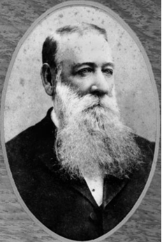
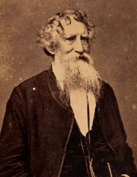
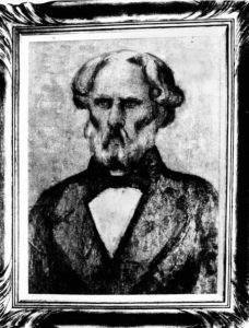
Biographies of John Bidwill, Maurice O’Connell, Christopher Rolleston, Stephen Simpson and William Wiseman are accessible on this website.
THE ROLE OF CROWN LANDS COMMISSIONERS
Commissioners of Crown Lands were representatives of the New South Wales government with magisterial power in their respective pastoral districts. They were charged with enforcing the provisions of the Acts relating to Crown Lands and with instituting any legal measures that they sought fit to prevent “intrusion, encroachment, and trespass” on those lands. (An Act for Protecting the Crown Lands of this Colony from Encroachment, Intrusion and Trespass (Act 4 Will. IV no. 10)
Governor Richard Bourke who appointed the first Commissioners, deemed it imperative that only specially chosen officials who were trustworthy, competent and physically fit, should take on this demanding role. They were to be “the eyes and ears of the government at Sydney on practically every aspect of life in their far-flung districts”.[3]
Their duties were wide ranging and at times onerous. They had responsibility for ensuring that law and order was maintained, halting frontier violence, controlling the Border Police Force placed under their command, issuing passports for convict travel and transfer, reserving sites for public purposes, granting licences to traders, undertaking surveys to mark pastoral district boundaries, exploring the district to discover further pastoral land and compiling a large number of detailed reports for the Colonial Secretary. These reports included[4]:
- Census of local population
- Observations on the condition of the Indigenous people
- Stock numbers
- Agricultural returns
- Conduct of Border Police officers
- Returns of hawkers’ licences
- Defaults on licence payments
- Reports relating to disputes between landholders
- Register of public buildings
- Register of runs
Commissioners were generally made Justices of the Peace to ensure that those accused of criminal activity received justice in a timely manner rather than waiting to appear before a Magistrate hundreds of miles from home. They were authorised to co-opt others such as Police or Justices of the Peace, to assist them when undertaking surveys or expeditions. For their services, Commissioners received £365 ($650) per annum while the Chief Commissioner of Crown Lands, George Barney, received £1600 ($2800) per annum.[5]
Each Commissioner was allocated a small number of troopers (usually between five and ten) to assist them in keeping the peace. These members of the Border Police Force were generally convicts, mostly ex-soldiers who had been transported for breaches of the military code. They were supplied with horses, equipment, rations and clothing but were expected to build their own barracks. Mounted troopers initially received 2s 6d (25cents) per day but this figure was increased to 3s 6d (35 cents) per day in 1851.[6]
[1] Queensland State Archives, Guide to the Records of the Crown Lands Offices 1842-1875, and the Crown Lands Commissioners’ Offices 1842-ca 1900, Queensland State Archives, Brisbane, 1993, pp. 4 and 5)
[2] New South Wales Government Gazette Issue 146, 1848 to Issue 47, 1859.
[3] McMartin, A. Public Servants and Patronage: The Foundations and Rise of the New South Wales Public Service, 1786-1859, Sydney University Press, Sydney, 1983, pp. 204 and 205.
[4] New South Wales Government Gazette, 11 September 1833, no. 80, p. 356. ‘Department of the Commissioner of Crown Lands’. https://nla.gov.au/nla.news-article12931879.
[5] Sydney Morning Herald, 7 November, 1851, p. 2.
[6] McMartin, A., Public Servants and Patronage: the Foundation and Rise of the New South Wales Public Service, 1786-1859, Sydney University Press, Sydney, 1983, pp. 205-207.
ADMINISTRATION OF PASTORAL DISTRICTS
Letters from the Commissioners to the Colonial Secretary and later to the Chief Commissioner of Crown Lands, held in the Queensland State Archives and the New South Wales State Archives and Records, provide valuable insights into life in the pastoral districts in the 1840s and 1850s and into the ways in which these areas were administered by the Commissioners. It is clear from these Letters that the Commissioners devoted most of their time to:
- Managing relations between Aborigines and white settlers
- Mediating disputes among local pastoralists
- Undertaking expeditions to discover new grazing lands and to monitor pastoral runs
- Writing reports
Managing relations between Aborigines and white settlers
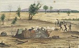
Commissioners were required to submit annual reports on the state of the Aborigines in their respective districts and to notify the Chief Commissioner of Crown Lands when clashes between Aborigines and white settlers occurred. Violent incidents were frequent, particularly in the early years of settlement. Lives were lost on both sides and property and stock stolen or destroyed. The Commissioners’ Reports indicate that conflict in the Wide Bay, Burnett and Leichhardt Districts was more serious, and in some instances more protracted, than in the Moreton Bay and Darling Downs districts with more frequent raids by Aborigines on settlers’ homes and massacres perpetrated by both sides. By the power invested in the Commissioners as Magistrates, it was their duty to investigate the circumstances surrounding each incident and to bring the perpetrators to justice.
In July 1842, Stephen Simpson, writing to the Colonial Secretary, expressed his concern over the ongoing hostilities in the Moreton Bay District which included the murder of two men, one employed by Francis Bigge and another employed by David McConnel. Similarly Christopher Rolleston reported a raid on Mr Bligh’s property on the Darling Downs where one man was killed and a number of sheep stolen. Further loss of life resulted from an Aboriginal raid on Mr. Isaac’s pastoral run. One worker was killed and many Aborigines were shot in retaliation.
Read more: Stephen Simpson’s letter to the Colonial Secretary dated 13 July 1842
Read more: Christopher Rolleston’s letter to the Colonial Secretary
Christopher Rolleston’s second Report to the Colonial Secretary indicates that the situation had eased by 1845. Clashes between Aborigines and settlers were becoming less frequent but some stock was still being lost. Rolleston reports on his attempts to befriend the local Indigenous people who were loath to trust Europeans following a spate of incidents in which shepherds and stockmen had assaulted Aboriginal women. Rolleston persevered in his endeavours by distributing blankets, tomahawks and clothes to the Aborigines and, as a result, he reported an improvement in relations.
Read more: Christopher Rolleston’s letter to the Colonial Secretary dated 1 January 1845
Later that year, in response to a request from the New South Wales government, Rolleston submitted a detailed report on the Indigenous people in the Darling Downs district in which he indicated that he was unable to give an accurate figure regarding the number of Aborigines in the Darling Downs district but that relations between Aborigines and pastoralists had improved and no violent incidents had occurred in the previous twelve months.
As relations between European settlers and Indigenous people were beginning to improve in the Darling Downs district, clashes between local settlers and Aborigines in the Wide Bay district increased and fatalities on both sides were common. John Bidwill expressed his growing concern over the ongoing hostilities, not just in remote areas but also close to the township of Maryborough and urged the Chief Commissioner of Crown Lands to assign more Border Police to the District.
Read more: John Bidwill’s letter to the Chief Commissioner of Crown Lands dated 17 January 1850
In 1852, Bidwill himself was the subject of a daring raid on his home and on the Police barracks situated on his property. Bidwill was forced to erect a high fence to deter the local Indigenous people from stealing firearms from the barracks, vegetables from his garden and sheep from his stock pens.
Read more: Bidwill’s letter to the chief Commissioner of Crown Lands dated 14 October 1852
The situation had scarcely improved by the time Arthur Halloran was appointed to the Wide Bay District in 1854 following the death of John Bidwill the previous year. Halloran wrote to the Chief Commissioner of Crown Lands urgently requesting that the Native Police Officers temporarily assigned to the District be permanently appointed as the number of Aborigines near Maryborough was increasing and white settlers, himself included, deemed it dangerous to travel anywhere unaccompanied.
Read more: Halloran’s letter to the Chief Commissioner dated 20 December 1853
The experience of William Wiseman, Commissioner for the Leichhardt, was similar. In his 1856 Report he recounts instances where lives were lost at Baimes and on another property owned by Mr Young situated between Mr. Larcom and the Great Dividing Range. He reported that the white settlers were in a state of panic and constantly in fear of attack by the Aborigines. It was his belief that the actions of the “treacherous natives” should be “followed with adequate punishment”. Although Wiseman felt duty bound to follow orders from the Chief Commissioner of Crown Lands, George Barney, which advocated a conciliatory approach towards the Indigenous people, his experiences led him to believe that conciliation would only lead to more loss of life and destruction of property. He urged the government to provide adequate protection to those who settled on the frontier rather than allowing police keeping duties to fall into the hands of individuals, many of whom abused their power.
Read more: William Wiseman’s letter to the Chief Commissioner of Crown Lands dated 5 January 1856
Mediating disputes among local pastoralists and dealing with complaints involving other officials
The New South Wales government appointed surveyors and Crown Lands Commissioners concurrently. Government surveyors were tasked with surveying the land prior to the first pastoral land sales and the sale of allotments in proposed town sites. Henry Wade was appointed as Surveyor in charge of the Moreton Bay District in 1842 and surveyed the site for both Brisbane and Ipswich. Francis McCabe surveyed the area around Port Curtis and the future township of Gladstone and Hugh Labatt was responsible for surveying the Wide Bay district. Relations between surveyors and the Crown Lands Commissioners were not always amicable. (Queensland Museum of Lands, Mapping and Surveying, ‘First surveys’, online at https://www.qld.gov.au/recreation/arts/heritage/museum-of-lands/first-survey)
Stephen Simpson, in his letter to the Colonial Secretary in 1842, recounts various altercations he had with Henry Wade as a result of Wade’s threatening behaviour, insulting conduct and neglect of duty. Wade was generally regarded as a trouble maker and his services as surveyor were eventually terminated in 1844.
Read more: Stephen Simpson’s letter to the Colonial Secretary dated 10 November 1842
Maurice O’Connell, Government Resident and Crown Lands Commissioner for Port Curtis and Surveyor Francis McCabe often clashed. In 1854, O’Connell complained to the Colonial Secretary that McCabe had failed to care for William Berry, a member of the survey team. Berry had become ill and when McCabe failed to act, Berry was required to seek help from O’Connell who was then obliged to arrange passage for Berry to Sydney to seek medical attention.
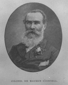
Read more: Maurice O’Connell’s letter to the Colonial Secretary dated 27 July 1854
The Commissioner of Crown Lands for Wide Bay, Arthur Halloran, spent much of his time settling disputes between local pastoralists. In 1853 he resolved an ongoing dispute regarding rightful ownership of new pastoral runs claimed by Messrs Brierly and MacTaggart. Halloran was required to investigate the matter by speaking to all the parties involved and examining the runs in person along with Surveyor Hugh Labatt. He then sent his report to the Chief Commissioner of Crown Lands.
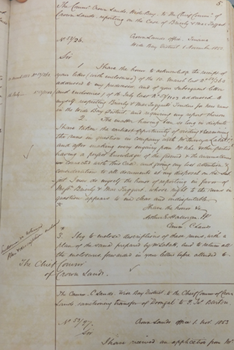
Read more: Halloran’s letter to the Chief Commissioner of Crown Lands dated 1 November 1853
Undertaking expeditions to discover new grazing lands and to monitor pastoral runs
Soon after their appointments as Crown Lands Commissioners, Stephen Simpson, Christopher Rolleston, John Bidwill and William Wiseman undertook arduous journeys to survey the extent of their pastoral districts and to report on the suitability of the land for either agriculture or sheep and cattle grazing.
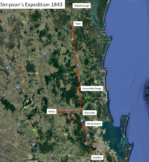
As early as March 1843, Stephen Simpson, accompanied by Mr Christopher Eipper, a German missionary based at Zion’s Hill (Nundah), four members of the Border Police Force and six prisoners who were put in charge of the bullock dray, set off from Simpson’s base at Woogaroo (Goodna) to determine the northern limits of the Moreton Bay district. They proceeded via Mount Brisbane to Kilcoy where Evan and Colin Mackenzie leased pastoral land, then went on to Durundur, leased by David Archer. Following a gruelling trek over the Conondale Range they reached the property of John Eales at Tiaro on 20 March. There they found the schooner Edward moored in a creek on the property which at that time was managed by Mr Joliffe. Simpson’s expedition returned to Woogaroo on 27 April having covered a distance of approximately 500 miles (800 kilometres).
In 1843 Christopher Rolleston also undertook a survey of his pastoral district which at that time had no defined northern boundary. The journey took him along the Boyne River and into the areas around Wide Bay. Apart from exploring new pastoral lands, he also reported on the climate and on the availability of timber.
Read more: Christopher Rolleston’s letter to the Colonial Secretary dated 28 December 1843
John Bidwill, acting on instructions from Governor William Denison, set out on a journey to survey a new route from Maryborough to Brisbane. Accompanied by a small group of men, he left his base at Tinana Creek and headed for Durundur near Woodford but he became disoriented in the rugged terrain around the Glasshouse Mountains and exhausted his food supplies. With assistance from the local Aborigines, he eventually arrived at Durundur and later returned to Maryborough but he was so debilitated by his experiences that he died soon after at the age of 38.
Read more: John Bidwill’s letter to the Chief Commissioner of Crown Lands dated 29 July 1851
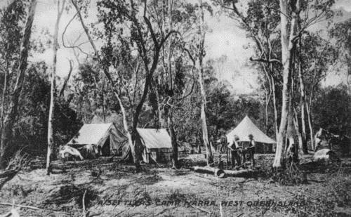
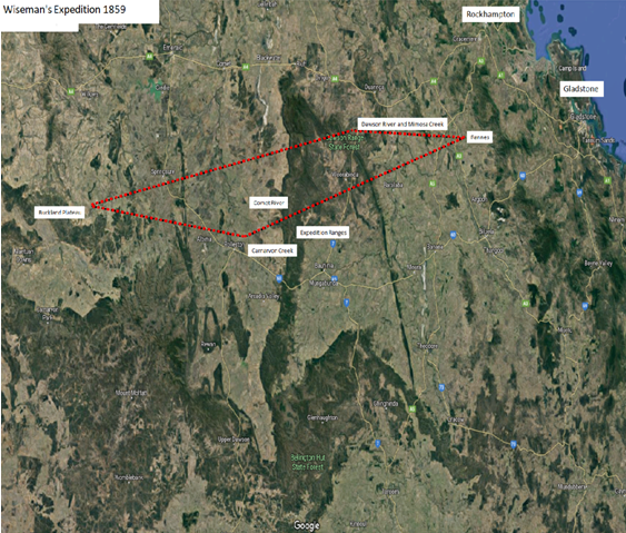
William Wiseman, appointed as Crown Lands Commissioner for the Leichhardt District in 1855, initially lived in a tent on Rannes station, owned by James Leith Hay. He regularly undertook dangerous journeys alone through rugged country as far south as Taroom and as far west as Peak Downs but in 1859 he began what proved to be a most ambitious and arduous expedition. With the help of Frederick Walker, a Native Police Officer, he ventured over the Bigge and Expedition Ranges to report on pastoral runs around the Comet River. He then rode as far south as Carnarvon Creek and west to the Buckland Plateau where he reported that the country was well suited for sheep and cattle but that some areas lacked a reliable source of water. The two men also explored Mimosa Creek and noted its confluence with the Dawson River. Wiseman’s expeditions often lasted up to three months through what he termed the “extraordinarily large and wild district” he was commissioned to administer. (Mc Donald, L., Rockhampton: A History of City and District, University of Queensland Press, Brisbane, 1981, pp. 45-46)
Report writing
One of the most time consuming duties of the Crown Lands Commissioners was the writing of reports demanded by the Colonial Secretary and the Chief Crown Lands Commissioner on behalf of the New South Wales Government. From an examination of the Commissioners’ Letterbooks, it appears that clerks were not automatically assigned to assist the Commissioners, at least in the early years of their appointment. Apart from annual reports on the condition of the local Indigenous people, Commissioners were required to report on their Border Police Force, on the condition of the land for stock and on the location for possible townships. Records also had to be kept regarding the number of convicts in the area, the population of the district, and the number and type of schools that had been established.
On his appointment to the Wide Bay Pastoral district in 1848, John Bidwill reported to the Colonial Secretary on the small settlement that had been established along the Mary River and on the surrounding district. He particularly noted the geological formations and the suitability of the land for pastoral purposes.
Read more: John Bidwill’s letter to the Colonial Secretary dated 30 December 1848
Commissioners were also required to write quarterly reports on the Conduct of their Border Police Officers and to submit other statistics including census figures, stock numbers, agricultural returns, register of pastoral runs and reports on schools in the district. This information was vital in determining the location of future settlements including the need for postal services, magistrates’ courts and schools and as an indication of future revenue the government could collect from pastoral leases and business licences.
Read more: Report of Conduct of Border Police; Return of Stock; Livestock; Return of Schools
Difficulties encountered by Commissioners of Crown Lands
When the Crown Lands Commissioners took up their positions it soon became apparent that their duties would far exceed those stated in their original terms of employment. The Districts to which they were assigned were rugged and isolated. Mail deliveries were erratic, and deliveries of food and other essentials were frequently delayed because of distance, poor roads, adverse weather conditions and lack of government funds. Commissioners were required to be resilient and adaptable when it came to handling local problems and coping with unexpected events.
When Maurice O’Connell was appointed as Government Resident and Crown Lands Commissioner of the Port Curtis pastoral district in 1854, he wrote to the Colonial Secretary outlining the unexpected costs incurred in establishing the settlement at Port Curtis and requesting an extra £1000 to defray his extra expenses. He noted the cost of employing stonemasons, carpenters and labourers was higher than expected and that the cost involved in the construction of stockyards and other preliminary work had not been budgeted for.
Read more: Maurice O’Connell’s letter to the Colonial Secretary dated 13 May 1854
Earlier that month, O’Connell, whose duties included Harbour Master, had been obliged to engage the services of Captain Graham of the schooner Tom Tough to salvage goods from the Dutch ship the Hester which had foundered on Kent Reef north east of Gladstone in April 1854. The crew of the Hester had survived but crew members of another Dutch ship, the Doelwych, which struck the reef at the same time, were never found.
Read more: Maurice O’Connell’s letter to Captain Graham date 3 May 1854
Due to his dual role of Government Resident and Crown Lands Commissioner for Port Curtis, O’Connell had many demands on his time. He was required to submit regular reports to the Colonial Secretary and to other government officials. As a result, shortly after his appointment he found it necessary to make application for the services of a clerk to assist him with the heavy load of correspondence required in the fulfilment of his duties.
Read more: Maurice O’Connell’s letter to Colonial Secretary dated 6 February 1854
In the Leichhardt district, William Wiseman was also experiencing difficulties. Apart from ongoing hostilities between settlers and the Indigenous people, disputes between pastoralists over property boundaries and the discomfort of living in a tent on Rannes station, he had to contend with a mail service that was constantly delayed because of bad weather, poor roads and regular attacks from the Aborigines. He was so concerned about the safety and reliability of the mail delivery that he felt it necessary to write to the Chief Commissioner of Crown Lands and suggest a different mail route.
Read more: William Wiseman’s letter to Chief Commissioner of Crown Lands dated 17 April 1855
SUMMARY
The men chosen to represent the New South Wales Government in the newly settled areas came from diverse backgrounds and were given wide-ranging administrative and judicial powers yet they received no preparation for the role of Crown Lands Commissioner. It is not surprising that some acted in an arbitrary and, at times, irrational manner but most were well chosen and largely successful.[1]
Their letters reveal how they adapted to their new environment and dealt with the daily challenges they faced, particularly in their dealings with the Indigenous people, in ensuring the safety of settlers and in establishing government services. Their regular reports provided vital information to the New South Wales government regarding the topography of the country, the suitability of land for pastoral or agricultural purposes, the activities of the Border Police Force, the establishment of pastoral runs and the future requirements for government infrastructure.
It was these early government officers who oversaw the orderly settlement of the land, established permanent settlements, explored new pastoral lands, pioneered new travel routes, introduced legal and administrative systems and established essential government services.
As the first government officials appointed to the new Pastoral Districts surrounding Moreton Bay, Crown Lands Commissioners had an enduring impact on regional areas in what later became the colony of Queensland.
[1] Martin, A. Public Servants and Patronage: The Foundation and Rise of the New South Wales Public Service, 1786-1859, Sydney University Press, Sydney, 1983.
REFERENCES
PRIMARY SOURCES
New South Wales Government, ‘An Act to restrain the unauthorized occupation of Crown Lands’, 29th July, 1836 online at www.austlii.edu.au/au/legis/nsw/num_act/cluoa1836n8418.pdf, accessed 26September 2017.
New South Wales State Archives: NRS 906 Colonial Secretary’s Special Bundles- Commissioners of Crown Lands. Reports re Border Police-Moreton Bay, 1843-1846, Record No: 4/7203.
New South Wales State Archives: NRS 906 Colonial Secretary’s Special Bundles- Commissioners of Crown Lands. Reports re Border Police-Moreton Bay, 1843-1847, Record No: 4/1141.1.
New South Wales State Archives: NRS 906 Colonial Secretary’s Special Bundles-New South Wales Civil Establishment-Returns of the Mounted Police 1831-1835; 1837-1841; 1843-1848; 1850, Record Nos: 4/7420 and 4/7205.
New South Wales State Archives, Moreton Bay, Record No: 4/26181.
Queensland State Archives Agency ID: 263, Moreton Bay District Survey Office, New South Wales.
Queensland State Archives, Commissioner for Crown Lands, Moreton District, Agency ID: 2144.
Queensland State Archives, Commissioner for Crown Lands, Wide Bay and Burnett, Agency ID: 10425.
Queensland State Archives, Diary of Commissioner of Crown Lands, Darling Downs, Series ID: 7094 Diary, Item ID: 269673.
Queensland State Archives, Leichhardt District Maps – G Series, Series ID: 1882, Item ID: 629065.
Queensland State Archives, Letterbook of letters sent by the Commissioner of Crown Lands, Moreton, Series ID: 7427, Item ID: 272324. Available online at: https://www.archivessearch.qld.gov.au/items/ITM272324.
Queensland State Archives, Letterbook of letters sent by the Commissioner of Crown Lands, Leichhardt, Series ID: 11963, Item ID: 7203.
Queensland State Archives, Letterbook of letters sent by the Commissioner of Crown Lands, Wide Bay and Burnett, Series ID: 11965, Item ID: 7205. https://www.archivessearch.qld.gov.au/items/ITM7205.
Queensland State Archives, Letterbook of letters sent by the Commissioner of Crown Lands, Wide Bay and Burnett, Series ID: 11965, Item ID: 7206. https://www.archivessearch.qld.gov.au/items/ITM7206.
Queensland State Archives, Letterbook – Government Resident, Port Curtis, Series ID: 6614 Letterbook, Item ID: 212594.
Queensland State Archives, Map of east and central Australia showing colony boundaries and pastoral districts c. 1860 (2 parts), Series ID: 4928, Series ID: 812103.
Queensland State Archives, Moreton District Maps – A Series, series ID: 2058, Item ID: 634892.
Queensland State Archives, Port Curtis District Maps – F Series, Series ID: 2115, Item ID: 635603.
Queensland State Archives, Wide Bay/Burnett District Maps – D Series, Series ID: 1872, Item ID: 628042.
State Archives of New South Wales, ‘Copies of letters to Commissioners of Crown Lands’ online at https://search.records.nsw.gov.au/permalink/f/1ebnd1l/ADLIB_RNSW110001201 accessed 9 August 2023.
BOOKS AND JOURNALS
‘Accounts and Papers New South Wales, Session 4, February-9 August 1845’, British Parliamentary Papers vol. 32, H.M. Stationery Office, London, 1845.
Armstrong, Barbara, ‘Australia’s First Homoeopath’, History of Homoeopathy in Australia, The Centre for Australian Homoeopathic History, online at https://www.homeopathyoz.org/homoeopathy/history-of-homoeopathy?showall=1, accessed 24 May 2017.
‘Barney, George (1792-1862)’, Australian Dictionary of Biography, National Centre of Biography, Australian National University, online at https://adb.anu.edu.au/biography/barney-george-1744/text1931, published first in hardcopy 1966, accessed 4 June 2017.
Brodie, M, ‘Sir Maurice Charles O’Connell’, Oxford Dictionary of Biography, online at https://www.oxforddnb.com/display/10.1093/ref:odnb/9780198614128.001.0001/odnb-9780198614128-e-20503?rskey=7j3iQP&result=8, accessed 22 November 2017.
Cilento, R., ‘The life and residences of the Hon. Stephen Simpson, M.D., J.P.,MLC of Warwickshire, Woogaroo and Wolston’, Journal of the Royal Historical Society of Queensland, vol. 8, no. 1, 1965-66, pp. 8-54.
‘Clark, William (1837-1918)’, Obituaries Australia, National Centre of Biography, Australian National University, online at https://oa.anu.edu.au/obituary/clark-william-226/text1639, accessed 12 June 2017.
Craig, W., Moreton Bay Settlement or Queensland before Separation together with A Brief Account of the Rise of the Colonies of Australasia, Watson Ferguson, Brisbane, 1925.
Cuneen, Chris, ‘Rolleston, Christopher (1817-1888)’, Australian Dictionary of Biography, National Centre of Biography, Australian National University, online at https://adb.anu.edu.au/biography/rolleston-christopher-4510/text 7359, published first in hardcopy 1976, accessed 4 June 2017.
Further papers relative to crown lands in the Australian colonies, Her Majesty’s Stationery Office London, 1854.
Ganter, R., ‘Eipper, Christopher (1813-1894)’ in Regina Ganter, German Missionaries in Australia – a web directory of intercultural encounters, 2016, https://missionaries.griffith.edu.au/, accessed 31 January 2018.
Gibbney, H. J., ‘O’Connell, Sir Maurice Charles (1812-1879)’, Australian Dictionary of Biography, National Centre of Biography, Australian National University, online at https://adb.anu.edu.au/biography/oconnell-sir-maurice-charles-4313/text6993, published first in hardcopy 1974, accessed 4 June 2017.
Gordon, Douglas, ‘Men of Medicine at Separation’, Medical Journal of Australia, 7 July 1962, pp. 1-10.
Grimes, J., Jacob Goode and His Burnett Inn, Xlibris, Nanango, Queensland, 2013.
Guildford, E., ‘Eales, John (1799-1871)’, Australian Dictionary of Biography, National Centre of Biography, Australian National University, online at https://adb.anu.edu.au/biography/eales-john-2014/text2469, published first in hardcopy 1966, accessed 12 February, 2018.
Herbert, D.A., ‘Bidwell, John Carne (1815-1853)’, Australian Dictionary of Biography, National Centre of Biography, Australian National University, online at https://adb.anu.edu.au/biography/bidwell-john-carne-1778/text1997, published first in hardcopy 1966, accessed 4 June 2017.
Hogan, J., The Gladstone Colony: An Unwritten Chapter of Australian History, Fisher Unwin, London, 1898.
Hogg, R., Men and Manliness on the Frontier: Queensland and British Columbia in the Mid-Nineteenth Century, Palgrave Macmillan, London, 2012.
Iltis, J., ‘Simpson, Stephen (1793-1869)’, Australian Dictionary of Biography, National Centre of Biography, Australian National University, online at https://adb.anu.edu.au/biography/simpson-stephen-2666, published first in hardcopy 1967, accessed 4 June 2017.
Langevad, G., Queale, A., Queensland Department of Community Services, Guide to the Letterbook (1855-1860) of William H. Wiseman Crown Lands Commissioner for the Pastoral District of Leichhardt/ compiled from a bound phot-copy of the original prepared by the late Alan Queale by Gerry Langevad, Queensland Department of Community Services, Brisbane, 1986.
Langevad, G., Pastoral Districts, G. Langevad, Brisbane, c. 1979.
Langevad, G., ‘Some original views around Kilcoy’, Queensland Ethnohistory Transcripts, vol. 1, no. 1.
McCarthy, G. and Rigby, R., ‘Bidwill, John Carne (1815-1853)’, Encyclopedia of Australian Science 2015, online at https://www.eoas.info/biogs/P000227b.htm, accessed 19 September 2017.
McDonald, L., Rockhampton: A History of City and District, University of Queensland Press, Brisbane, 1981.
McDonald, L. ‘Settlement Patterns in the Upper Burnett and Lower Port Curtis Districts in the Nineteenth Century’, Journal of the Royal Historical Society of Queensland, vol. 16, no. 8, November 1997, pp. 333-342.
McKinnon, F., ‘Early Pioneers of the Wide Bay and Burnett’, Historical Society of
Queensland Journal, vol. 3, no. 2, October 1940, pp. 90-99.
McKinnon, F., ‘Early Days of Maryborough’, Historical Society of Queensland Journal, vol. 3, no. 6, 1947, pp. 473-484.
Maher, J.T., ‘Maurice Charles O’Connell: a biographical sketch’, Journal of the Royal Historical Society of Queensland, vol. 7, no. 2, 1963, pp.245-262.
McMartin, A., Public Servants and Patronage: The foundation and rise of the New South Wales Public Service, 1786-1859, Sydney University Press, Sydney, 1983.
Maiden, J., The Sydney Botanic Garden: Biographical notes concerning the Officers in Charge, S. T. Leigh and Company Printers, Sydney, 1903, online at www.nla.gov.au/nla.obj-35896092/view?searchTerm=J.+C.Bidwill, accessed 30 October 2017.
Map of South-east Queensland showing district boundaries 1848, J. Arrowsmith, London.
Morrison, W., The Aldine History of Queensland, Volume.1, The Aldine Publishing Company, Sydney, 1888.
New South Wales State Archives, Commissioners of Crown Lands Guide, online at www.records.nsw.gov.au/archives/collections-and-research/guides-and-indexes/commissioners-crown-lands-guide, accessed 4 June 2017.
Queensland State Archives, Guide to the Records of the Crown Lands Office 1842-1875 and the Crown Lands Commissioners’ Office, 1842-ca 1900, Queensland State Archives, Brisbane, 1993.
Papers relative to Crown Lands in the Australian Colonies, Her Majesty’s Stationery Office, London, 1854.
Pugh, T., Pugh’s Almanac, Directory and Law Calendar for 1859, General Printing Office, Brisbane, 1859.
Read, S., ‘Bidwill of Wide Bay: A botanist cut short’, Queensland Review, vol. 19, no. 1, 2012, pp.75-88.
Simpson, E. V., ‘Stephen Simpson, M.D., M.L.C.’, Journal of the Historical Society of Queensland, vol. 5, 1953, pp. 794-803.
Simpson, S. and Langevad, T., ‘The Simpson letterbook/ transcribed by Gerry Langevad’, Cultural and historical records of Queensland, no.1, October 1979. https://espace.library.uq.edu.au/view/UQ:289630.
Taylor, R., ‘Early Settlement in the Surat-Mount Abundance Area’, Journal of the Royal Historical Society of Queensland, vol. 5, no. 4, pp. 1240-1253.
Toowoomba and Darling Downs Family History Society Inc., Initial Settlement on the Darling Downs 1843-1852, a transcription of Rolleston’s Records, 2008. [CD ROM]
Walker, J., Jondaryan Station: The Relationship between Pastoral Capital and Pastoral Labour 1840-1890, University of Queensland Press, Brisbane, 1988.
Wallis, N., The doctor of Woogaroo Station: the Story of Stephen Simpson MD, JP, MLC – his life in England and Europe and particularly his time at Woogaroo Station (Goodna) Queensland during 1843 to 1852, Noel Wallis, Forest Lake, Queensland, 2010.
Waterson, D.B., Biographical Register of the Queensland Parliament 1860-1929, Casket Publications, Sydney, 2001.
Waterson, D.B., ‘Gregory, Sir Augustus Charles (1819-1905)’, Australian Dictionary of Biography, National Centre of Biography, Australian National University, online at https://adb.anu.edu.au/biography/gregory-sir-augustus-charles-3663/text5717, published first in hardcopy 1972, accessed online 4 June 2017.
Wroe, M., Paving the Way, Butkus Printing, Maryborough, 2000.
NEWSPAPERS AND MAGAZINES
Argus, Melbourne 10 April 1888, p. 8, ‘Death of Mr. Christopher Rolleston CMG’. https://nla.gov.au/nla.news-article6116224.
Australian Town and Country Journal 7 June 1879, p. 17. ‘Christopher Rolleston C.M.G’. https://nla.gov.au/nla.news-article70939040.
Australian Town and Country Journal, 20 November 1875, p. 13. ‘Sir Maurice Charles O’Connell’. https://nla.gov.au/nla.news-article70587092.
Australian Town and Country Journal, 29 March 1879, p. 17. ‘Sir Maurice Charles O’Connell’. https://nla.gov.au/nla.news-article70936679.
Australasian Sketcher with Pen and Pencil, 19 February 1876, p. 183. ‘Sir Maurice Charles O’Connell’. https://nla.gov.au/nla.news-article60606443.
Brisbane Courier, Brisbane, 22 May 1869, p. 5. ‘Death of Dr Simpson’. https://nla.gov.au/nla.news-article1315128.
Central Queensland Herald, Rockhampton, 14 July 1949, p. 3. ‘Early Settlers: The Leith-Hays and Rannes Station’. https://nla.gov.au/nla.news-article76218691.
Freeman’s Journal, Sydney, 13 November 1851, p. 10. ‘Department of the Chief Commissioner of Crown Lands’. https://nla.gov.au/nla.news-article115765881.
Maitland Mercury and Hunter River General Advertiser, 6 January 1863, p. 3. ‘Real Property Act’.
Maryborough Chronicle, Wide Bay and Burnett Advertiser, 10 March 1903, p. 2. ‘Fifty Years Ago’. https://nla.gov.au/nla.news-article148192719.
Moreton Bay Courier, Brisbane, 1 August 1857, p. 4. ‘The Leichhardt District‘. https://nla.gov.au/nla.news-article3724437.
Moreton Bay Courier, Brisbane, 14 February 1861, p. 2. ‘Commission of the Peace’. https://nla.gov.au/nla.news-article3721364.
New South Wales Government Gazette, Sydney, 11 September 1833, no. 80, p. 356, ‘An Act for protecting the Crown Lands of this Colony from Encroachment, Intrusion, and Trespass’.
New South Wales Government Gazette, Sydney, 6 April, 1839, no. 405, p. 393, ‘Anno secondo Victoria Regina No. 27’.
New South Wales Government Gazette, Sydney, 5 April, 1842, no. 27, p.509, ‘His Excellency the Governor has been pleased to appoint Stephen Simpson Esquire to be a Commissioner of Crown Lands’.
New South Wales Government Gazette, Sydney, 3 January, 1843, no. 1, p. 2.
New South Wales Government Gazette, Sydney, 19 May 1843, no. 42, p. 676.
New South Wales Government Gazette, Sydney, 12 November 1847, no. 98, p. 1239.
New South Wales Government Gazette, Sydney, 7 November 1848, no. 127 Supplement, p. 1644, ‘Crown Lands Beyond the Settled Districts’.
New South Wales Government Gazette, Sydney, 26 December 1848, no. 146, p. 1862.
New South Wales Government Gazette, Sydney, 30 October 1849, no. 148, p. 1505.
New South Wales Government Gazette, Sydney, 10 January 1854, issue no. 3, p. 51.
New South Wales Government Gazette, Sydney, 4 July 1854, issue 79, p. 1371.
New South Wales Government Gazette, Sydney, 5 January 1855, issue no. 2, p. 15.
Pittsworth Sentinel, 20 October 1953, p.1, ‘Romance of Downs Place Names’. https://nla.gov.au/nla.news-article198512727.
Queenslander, Brisbane, 23 August 1919, p. 41. ‘Bidwell’s Grave’. https://nla.gov.au/nla.news-article22375668.
Rockhampton Bulletin and Central Queensland Advertiser, Rockhampton, 23 September 1871, p. 2. ‘Family Notices’. https://nla.gov.au/nla.news-article51583191.
Statistical Register of Queensland, 1861, ‘Index of Officers to Civil Establishment, Lands, Pastoral’, Section 7, p. 11.
Sydney Morning Herald, Sydney, 7 November 1851, p. 2. ‘Department of the Chief Commissioner of Crown Lands’. https://nla.gov.au/nla.news-article12931879.
Telegraph, Brisbane, 28 May 1890, p. 4. ‘Death of Mr. A. E. Halloran’. https://nla.gov.au/nla.news-article176137836.
Truth, Brisbane, 28 May 1911, p. 10. ‘Chronicles of Queensland’. https://nla.gov.au/nla.news-article201749877.
WEBSITES
Encyclopedia of Australian Science, ‘Rolleston Christopher (1817-1888)’, online at https://www.eoas.info/biogs/P002527b.htm, accessed 19 October 2017.
Find a Grave, ‘William Wiseman’, online at www.findagrave.com/memorial/68258341/william-henry-wiseman, accessed 18 November 2017.
Monument Australia, ‘John Carne Bidwill’, online at www.monumentaustralia.org.au/australian_monument/display/105437, accessed 21 October 2017.
Monument Australia, ‘Sir Maurice Charles O’Connell’, online at www.monumentaustralia.org.au/themes/people/government—colonial/display/92713-sir-maurice-charles-0%60connell.
Permaculture Research Institute, ‘The Bunya-Bunya Pine (Araucaria Bidwillii)’, online at https://www.permaculturenews.org/2013/11/27/the-bunya-bunya-pine-araucaria-bidwillii/, accessed 18 December 2017.
Queensland Government [AU] ‘John Carne Bidwill’, online at https://www.qld.gov.au/recreation/arts/heritage/museum-of-lands/surveyors/john-bidwill, accessed 17 December 2017.
Queensland Museum of Lands, Mapping and Surveying, ‘First surveys’, online at https://www.qld.gov.au/recreation/arts/heritage/museum-of-lands/first-survey, accessed 28 May 2018.
Queensland Museum of Lands, Mapping and Surveying, ‘Parishes and historical land administration’, online at www.qld.gov.au/recreation/arts/heritage/museum-of-lands/administration/parishes, accessed 19 September 2017.
Queensland Museum of Lands, Mapping and Surveying, ‘Surveying history’, online at https://www.qld.gov.au/recreation/arts/heritage/museum-of-lands/survey-history, accessed 28 May 2018.
Queensland Parliament, ‘Colonel Sir Maurice O’Connell’, online at www.parliament.qld.gov.au/explore/history/overview, accessed 28 September 2017.
State Archives and Records Authority of New South Wales [AU] online at https://www.records.nsw.gov.au/agency/3500, accessed 17 December 2017.
State Archives and Records Authority of New South Wales [AU], ‘Commissioner of Crown Lands for the Darling Downs’, online at https://www.records.nsw.gov.au/agency/3500, accessed 17 December 2017.
Wikipedia, ‘Friend Park, Barney Point’, online at https://en.wikipedia.org/w/index.php?title=Friend_Park_Barney_Point&oldid=783588049, accessed 8 June 2017.
Wikipedia, ‘John Carne Bidwill’, online at https://en.wikipedia.org/w/index.php?title=John_Carne_Bidwill&oldid=786737091, accessed 24 October 2017.
Wikipedia, ‘Maurice Charles O’Connell (Australian politician), online at https://en.wikipedia.org/w/index.php?title=Maurice_Charles_0%27Connell_(Australian_politician)&oldid=794895502, accessed 20 November 2017.

